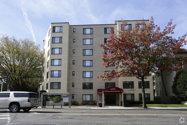
Property Record
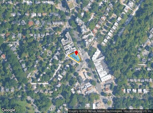
5100 Connecticut Ave Nw, Washington, DC 20008
NEARBY LISTINGS FOR SALE OR LEASE
Property Detail
5100 Connecticut Ave Nw
Washington-Arlington-Alexandria, DC-VA-MD-WV
Chevy Chase
1879-0018
SQUARE 1879 LOT 0018 NBHD: CHEVY CHASE
Apartment
District of Columbia
X
District of Columbia
1100010004C
18
2025
0.22 AC
2025
Chevy Chase DC
001100
Washington, DC
27,237 SF
DEMOGRAPHICS near 5100 Connecticut Ave Nw
1 Mile
3 Mile
5 Mile
2024 Total Population
25,390
239,788
643,514
2029 Population
22,804
221,988
606,527
Pop Growth 2024-2029
(10.19%)
(7.42%)
(5.75%)
Average Age
42
41
39
2024 Total Households
11,729
108,427
291,580
HH Growth 2024-2029
(11.05%)
(7.98%)
(6.51%)
Median Household Inc
$139,684
$127,023
$118,616
Avg Household Size
2.10
2.10
2.10
2024 Avg HH Vehicles
1.00
1.00
1.00
Median Home Value
$1,042,938
$939,945
$838,748
Median Year Built
1954
1952
1960
Nearby Places
Map Layers
Map Styles
 Street
 Aerial
- Restaurants
- Banks
- Shops
- Fitness
- Groceries
PUBLIC TRANSPORTATION
TRANSIT/SUBWAY
Tenleytown-Au (Red Line - Washington Metropolitan Area Transit Authority Metrorail (Metrorail))
DRIVE
WALK
Distance
Tenleytown-Au (Red Line - Washington Metropolitan Area Transit Authority Metrorail (Metrorail))
1 min
15 min
0.8 mi
Van Ness-Udc (Red Line - Washington Metropolitan Area Transit Authority Metrorail (Metrorail))
DRIVE
WALK
Distance
Van Ness-Udc (Red Line - Washington Metropolitan Area Transit Authority Metrorail (Metrorail))
2 min
17 min
0.9 mi
Friendship Heights (Red Line - Washington Metropolitan Area Transit Authority Metrorail (Metrorail))
DRIVE
WALK
Distance
Friendship Heights (Red Line - Washington Metropolitan Area Transit Authority Metrorail (Metrorail))
2 min
18 min
0.9 mi
COMMUTER RAIL
Silver Spring (BRUNSWICK - WASHINGTON - Maryland Area Regional Commuter Trains (The MARC), Brunswick Line - Maryland Area Regional Commuter Trains (The MARC))
DRIVE
WALK
Distance
Silver Spring (BRUNSWICK - WASHINGTON - Maryland Area Regional Commuter Trains (The MARC), Brunswick Line - Maryland Area Regional Commuter Trains (The MARC))
9 min
4.9 mi
Kensington (BRUNSWICK - WASHINGTON - Maryland Area Regional Commuter Trains (The MARC), Brunswick Line - Maryland Area Regional Commuter Trains (The MARC))
DRIVE
WALK
Distance
Kensington (BRUNSWICK - WASHINGTON - Maryland Area Regional Commuter Trains (The MARC), Brunswick Line - Maryland Area Regional Commuter Trains (The MARC))
12 min
5.3 mi
AIRPORT
Ronald Reagan Washington Ntl
DRIVE
WALK
Distance
Ronald Reagan Washington Ntl
19 min
9.8 mi
Washington Dulles International
DRIVE
WALK
Distance
Washington Dulles International
43 min
24.2 mi
Baltimore/Washington International Thurgood Marshall
DRIVE
WALK
Distance
Baltimore/Washington International Thurgood Marshall
48 min
35.2 mi
Freight Ports
Port of Baltimore
DRIVE
WALK
Distance
Port of Baltimore
53 min
38.1 mi
Nearby Properties
Address
Land Use
TOTAL SIZE
Lot Size
Zoning
Address
Land Use
TOTAL SIZE
Lot Size
Zoning
70,860 SF
1,616.16 AC
R-1A;UNZON
Address
Land Use
TOTAL SIZE
Lot Size
Zoning
553,914 SF
55.91 AC
R-1B
Address
Land Use
TOTAL SIZE
Lot Size
Zoning
900,000 SF
12.60 AC
RA-4
Address
Land Use
TOTAL SIZE
Lot Size
Zoning
788,000 SF
CR5
Address
Land Use
TOTAL SIZE
Lot Size
Zoning
247,900 SF
170.58 AC
RA-2;UNZON
Address
Land Use
TOTAL SIZE
Lot Size
Zoning
Address
Land Use
TOTAL SIZE
Lot Size
Zoning
795,214 SF
MU-5A
Address
Land Use
TOTAL SIZE
Lot Size
Zoning
997,890 SF
6.30 AC
CR3.0
Address
Land Use
TOTAL SIZE
Lot Size
Zoning
1,452,667 SF
43.94 AC
R-1B;RA-1
Address
Land Use
TOTAL SIZE
Lot Size
Zoning
10,158 SF
97.34 AC
MU-10;MU-1
Address
Land Use
TOTAL SIZE
Lot Size
Zoning
902,764 SF
2.87 AC
MU-5A
Address
Land Use
TOTAL SIZE
Lot Size
Zoning
1,180,000 SF
35.70 AC
R90
Address
Land Use
TOTAL SIZE
Lot Size
Zoning
579,243 SF
1.89 AC
CR8.0
Address
Land Use
TOTAL SIZE
Lot Size
Zoning
750,000 SF
3.48 AC
CR5.0
Address
Land Use
TOTAL SIZE
Lot Size
Zoning
362,643 SF
CR
Address
Land Use
TOTAL SIZE
Lot Size
Zoning
244,615 SF
19.61 AC
R-1A/FH
Address
Land Use
TOTAL SIZE
Lot Size
Zoning
69.17 AC
R-1B
Address
Land Use
TOTAL SIZE
Lot Size
Zoning
930,240 SF
2.32 AC
CR3.0
Address
Land Use
TOTAL SIZE
Lot Size
Zoning
505,408 SF
12.46 AC
RA-1
Address
Land Use
TOTAL SIZE
Lot Size
Zoning
287,183 SF
0.59 AC
CR5
Address
Land Use
TOTAL SIZE
Lot Size
Zoning
516,328 SF
13.19 AC
R-1B
Address
Land Use
TOTAL SIZE
Lot Size
Zoning
451,948 SF
1.08 AC
CR5.0
Address
Land Use
TOTAL SIZE
Lot Size
Zoning
316,393 SF
13.61 AC
R-1A
Address
Land Use
TOTAL SIZE
Lot Size
Zoning
1,053,971 SF
4.19 AC
R-1A/FH;RA
Address
Land Use
TOTAL SIZE
Lot Size
Zoning
13,040 SF
166.53 AC
PDR-1;R-1A
Address
Land Use
TOTAL SIZE
Lot Size
Zoning
227,526 SF
7.95 AC
MU-4;R-2;R
Address
Land Use
TOTAL SIZE
Lot Size
Zoning
280,000 SF
0.82 AC
RA-2
Address
Land Use
TOTAL SIZE
Lot Size
Zoning
426,350 SF
8.22 AC
CR2.0
Address
Land Use
TOTAL SIZE
Lot Size
Zoning
918,256 SF
5.26 AC
RA-2
Address
Land Use
TOTAL SIZE
Lot Size
Zoning
302,861 SF
16.30 AC
R-1A
The World's #1 Commercial Real Estate Marketplace
Connect with us
© 2025 CoStar Group
The information above has been obtained from sources believed reliable. While we do not doubt its accuracy we have not verified it and make no guarantee, warranty or representation about it. It is your responsibility to independently confirm its accuracy and completeness. Any projections, opinions, assumptions, or estimates used are for example only and do not represent the current or future performance of the property. The value of this transaction to you depends on tax and other factors which should be evaluated by your tax, financial, and legal advisors. You and your advisors should conduct a careful, independent investigation of the property to determine to your satisfaction the suitability of the property for your needs.